OML-Highway description
Model characteristics
OML-Highway is a local-scale Gaussian air pollution model specially designed to describe the dispersion of air pollutants along roads within an open roadside environment (Jensen et al., 2004;2010). It is based on the OML model (Olesen et al., 2007) which is designed for air quality assessment based on point and area sources. The OML-Highway represents road sources as area sources. The parameterisation for the initial dispersion is based on the formulation in the OSPM model (Berkowicz, R., 2000), but is slightly modified with regard to highways. In the OML-Highway model traffic produced turbulence (TPT) is depending on traffic intensity, type of vehicles (light and heavy-duty vehicles) and travel speed as in the OSPM model but decays in an exponential manner with distance from the road. The European emission model COPERT IV is integrated into the OML-Highway model. The OML-Highway includes simple photo-chemistry and is able to model NO2 taking into account chemical transformation between NO, NO2 and O3. The model includes algorithms that enable modelling of the effects of noise barriers on the dispersion of air pollution. The time step in the model is one hour.
GIS functionality
OML-Highway has been integrated into SELMAGIS, a GIS environment developed by Lohmeyer GmbH & Co. KG, Germany which runs as an extension to ArcGIS (Jensen et al., 2010). The purpose of SELMAGIS is to integrate sophisticated dispersion models into a framework with the capability to prepare input data and analyse model output by utilising the spatial capabilities of a GIS. OML-Highway is such a model.
Input requirements
OML-Highway requires inputs on
OML-Highway requires a digital GIS road network with traffic data (average daily traffic, travel speed, and share of heavy-duty vehicles). Based on these data the OML-Highway is able to automatically generate emissions based on the European emission model COPERT IV that is integrated into the OML-Highway model. Emissions include NOx, NO2, PM exhaust, PM2.5, PM10, CO, benzene, and CO2 (based on fuel consumption).
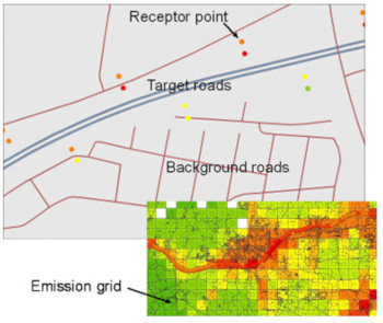

The digital road network has to be divided into target roads and background roads by assigning an attribute. Target roads are typically the roads where the user wants to calculate air quality along the road for specified receptor points. The target roads are automatically subdivided into small areal sources. The background roads are all other roads that contribute to the background levels at the target roads. The user can specify a user-specified grid (typically 1x1 km2) to automatically calculate the emissions from the background roads. Other sources than road sources may be imported.
The OML-Highway model also requires time-series data for regional background concentrations.
OML-Highway requires processed meteorological data, which can be provided by the OML meteorological preprocessor. This preprocessor calculates turbulence parameters based on, e.g., synoptic and upper air data. A user-friendly simplistic special version of the OML meteorological preprocessor has been integrated into the OML-Highway model that only requires synoptic data.
The model includes algorithms that enable modelling of the effects of noise barriers on the dispersion of air pollution. The user has to specify the height and location of the noise barrier.
OML-Highway makes it easy to generate receptor points e.g. along target roads in certain distances or import of receptor points that represent all buildings in a certain area.
Outputs
Model results may be time-series or various statistical values like annual mean or percentiles for specified receptor points. The model can estimate concentrations of NOx, NO2, O3, number of particles, PM2.5, PM10, CO and benzene provided that regional concentrations are available for these pollutants.

Validation
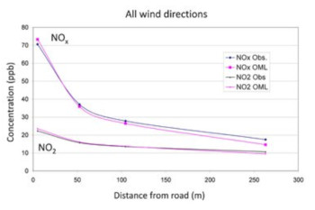
OML-Highway has been successfully evaluated against measurement datasets from Denmark (Jensen et al. 2004;Wang et al. 2010) and Norway for the pollutant of NOx (= NO+NO2) and it has also been compared to other similar models (Berger et al., 2010).
Model karakteristika
OML-Highway er en lokal-skala gaussisk luft forurening model specielt designet til at beskrive spredning af luftforurenende stoffer langs veje i et åbent vejmiljø (Jensen et al., 2004, 2010). Det er baseret på OML-modellen (Olesen et al., 2007) som er designet til luftkvalitetsvurdering baseret på kilder fra punkter og områder. OML-motorvejen repræsenterer kilder fra veje som kilder fra områder. Parametrering for den indledende spredning er baseret på formuleringen i OSPM modellen (Berkowicz, R., 2000), men er ændret en smule for motorveje. I OML-Highway modellen er den trafik producerede turbulens (TPT) afhængig af trafik, intensitet, type køretøjer (lette og tunge køretøjer) og bilernes hastighed som i OSPM modellen, men aftager på en eksponentiel måde med afstanden fra vejen. Den europæiske udledningsmodel COPERT IV er integreret i OML-Highway. OML-Highway omfatter simple foto-kemi og er i stand til at modellere NO2 og tager hewnsyn til kemisk omdannelse mellem NO, NO2 og O3. Modellen indeholder algoritmer, der aktiverer modellering effekten af støjskærme på spredningen af luftforurening. Tidsmæsssige trin i modellen er en time.
GIS funktionalitet
OML-Highway er blevet integreret i SELMAGIS, som er en miljø GIS udviklet af Lohmeyer GmbH & Co KG, Tyskland, som er en udvidelse til ArcGIS (Jensen et al., 2010). Formålet med SELMAGIS er at integrere avancerede spredningsmodeller ind i et system, som har kapacitet til at bearbejde data og skabe analysemodeller ved at udnytte de rumlige kapaciteter fra GIS. OML-Highway er sådan en model.
Krav til input
OML-Highway kræver input fra
OML-Highway kræver GIS´s digitale vejnetsdata om trafikken ( gennemsnitslige daglige trafik, rejsehastighed, og andelen af tunge køretøjer ). Baseret på disse data kan OML-Highway automatisk generere udledninger baseret på den europæriske udledningsmodel COPERT IV, som er integreret i OML-Highway-modellen. Udledningerne inkludere NOx, NO2, PM exhaust, PM2.5, PM10, CO, benzen, og CO2 (baseret på brændstofforbruget).
Validering
OML-Highway er med succes evalueret med datasæt fra Danmark (Jensen et al. 2004; Wang et al. 2010) og Norge for det forurenende stof NOx (= NO + NO2), og det er også blevet sammenlignet med andre lignende modeller (Berger et al., 2010).


